December 25, 2022

Arunachal Pradesh Diary : Chapter 1 - Bomdila and Dirang

Travel is an investment in oneself. 

Ever since our first trip to the North-East India in 2019, we were eager to come back and explore the hidden gems. The pandemic delayed the next big travel, but finally we got a chance to come to the land of rising Sun, Arunachal Pradesh, in October 2022.


Mountains Calling

Arunachal Pradesh was formed from the earlier NEFA (North-East Frontier Agency). It is a border state having international borders with China, Myanmar and Bhutan. This hilly region of Himalayas has witnessed the 1962 India-China war. Our trip was on the western side of Arunachal, covering Dirang, Tawang and Bumla. In the first chapter, our focus will be on Bomdila and Dirang.


Before we begin, a moment of appreciation for the BRO (Border Road Organization) that takes care of the road infrastructure in this difficult terrain. They are continuously improving the road infrastructure in this region to make it all-weather accessible. Many thanks to Gaurav Gupta sir, Rakesh Bhatti sir, Zuber Ahmad Sir and others from BRO whose hospitality made our trip extra special.

How to reach:

  • Nearest airport is Guwahati Airport. The road journey from Guwahati to Tawang is better to be broken into 2 days due to the hilly region.
  • We stayed in Dirang  (Dirang Dzong homestay) during our onward journey and stayed near Sappers with our BRO friends during the return journey. 
  • The towns in Arunachal are located on the hills and are sparsely populated. The journey on the mountain roads is mostly along the side of the river. 

Weather:

  • Once you enter Arunachal Pradesh via land route, the altitude keeps on rising and temperature keeps on falling. Keep your winter clothes ready.
  • Extreme winter starts November month onwards, but the cold climate remains throughout the year. It can be understood by the observation that there were no fans in any homestays we stayed!

Culture:

  • While Christianity is a major religion in Arunachal Pradesh, people of the Western districts of West Kameng and Tawang are mostly Buddhist. 
  • Hindi is quite commonly used by the locals in communication.

Bomdila

We entered Arunachal Pradesh via Balemu check point, quite close to the Bhutan border. As Arunachal Pradesh comes under the restricted area, you'll need Inter-Line Permit (ILP) to enter the state. It can be obtained online.

We crossed picturesque views of Kalaktang and Rupa before reaching Bomdila. This was an 10-hour journey from the Guwahati Airport. The mountain roads are full of cabbage plantations on this route.  Bomdila is a headquarter of the West Kameng district. Bomdila is mainly famous for the beautiful Bomdila monastery. We spent a quite evening here exploring the monastery.


Bomdila Monastery

A drone view of the same monastery can be seen on the YouTube channel of our friends Nini and Jay who met us first time at this Monastery. - https://www.youtube.com/watch?v=taHxMGkmIVw

Dirang

Dirang is at an hour's distance from Bomdila. This is where we had our first stay at the Dirang Dzong homestay. During our return, we stayed at Sappers which is quite close to Dirang. The beautiful hilly region of Dirang was a pleasant surprise for us. For the nature lovers, this place has a lot to offer. 


Seven Brothers' Monument, Dirang

There is a monument in the memory of seven brothers who laid down their lives protesting against the tyrant king along side the road. The old Dirang Monastery was at walkable distance from our stay. It is a small monastery and was under renovation during our visit. The new Thuksang Dargeyling Monastery was built recently in 2017 and was inaugurated by his Holiness the 14th Dalai Lama. The new monastery is located on a hill top and it takes approx. 30 minutes to reach there. If you are looking for calmness and peace, this scenic monastery has got plenty of them. This beautiful structure overlooking Dirang offers great visuals for photographers.


Thuksang Dargeyling Monastery


Dirang is also a good base to explore nearby locations, like Mandala Top and Sangti Valley. Mandala Top, as the name suggests, is located on the top of a mountain, approx. 25 kms from Dirang. On a non-cloudy day, the hairpin road offers scenic view of the surrounding mountain ranges. On top, there is a recently constructed circular monument of 108 stupas. This is a good place for a day picnic.


Mandala Top

While Mandala Top is located on the top of a hill, Sangti Valley offers a picturesque location of a village along the river. The road to reach valley is not smooth but it crosses beautiful plantations of oranges, tomatoes and kiwis. The white sandy river beach of valley is a good place to relax and enjoy the chilled water. There are homestay available near the valley to stay here overnight. That would be quite an experience for sure.


Sangti Valley

We had planned our trip for Tawang, but Dirang came out as a beautiful surprise. There are few more surprises on our journey towards Tawang, to be explored in the subsequent chapters!

Head to the Chapter 2 here.

More photos of Arunachal trip can be seen at - https://www.instagram.com/nimeshddesai/

November 12, 2019

Statue of Unity - A Modern Marvel

Finally we got a chance to visit Statue of Unity just before it's first anniversary during Oct 2019. The statue is an architectural marvel built to honor the one of the greatest Indian, Sardar Vallabhbhai Patel.

I have done reasonable amount of travel within India, from north to south and from east to west. One complain that I always have is that our governments have almost stopped building new tourism attractions for quite some time. In most cities and states, the places of tourism belong to British or pre-British era, or places of worships by independent organisations (like Akshardham). I have also seen during my foreign stay how Indian Freedom struggle has been reduced to couple of people in International media. For these reasons, I am quite happy to have a modern monument that not only establishes the legacy of national leaders but also becomes a major tourism destination. It also showcases the skills of Indian companies and engineers to the whole world.

Trivia - The height of 182 mtrs was chosen to signify 182 number of seats in the Gujarat Legislative Assembly.


The Giant talking to the mountains


Reaching Statue of Unity:
  • Statue of Unity is located on Sadhu Bet, Near Sardar Sarovar Dam, Kevadia, Gujarat. Statue site is accessible by road from Gujarat's major cities, nearest one is Vadodara. It is at 90 kms distance from Vadodara Airport, a 2 hour drive. The road is newly developed and is a scenic drive along which we can see Pavagadh Hills in distance.
  • Booking for Statue viewing can be done online at https://soutickets.in/. The dates open before 30 days. Tickets are also available at the ticket counters at Statue site.
  • Statue site opens at 8:00 am in the morning, and entry to museum and statue is allowed till 6:00 pm.
Staying at Statue of Unity
  • Though we made a day trip mainly to visit Statue and Dam, with the addition of Dino Park, Valley of Flowers, Cactus Garden, Butterfly Park and other projects, it is difficult to cover everything in a single day. There are multiple tent-cities near Kevadia for the overnight stay whose booking can be done online. With the increase in tourists, a number of new stay options are likely to come in future.
There is a parking space for private vehicles at the entrance of the Statue site. There are AC buses to reach Statue and other locations from here. These buses runs free of charge, and are quite frequent. Main statue is 6 km from the parking space.

The first place we visited after reaching here was Sardar Sarovar Dam view point. It is a small climb along local shops from where 163 mtr high dam can be seen. It is the biggest dam in the state of Gujarat, and provides water to arid regions of Gujarat, Rajasthan and Maharashtra.

Trivia - 1.2 km long Sardar Sarovar Dam is the fifth tallest dam in India.


Sardar Sarovar Dam

As the Valley of flowers was closed due to security arrangements for Prime Minister's visit, we directly headed to the Statue site from the dam view point. It is a huge space with separate entry and exit. There is a decent size cafeteria where good veg food is available, though it can be crowded during peak season. There is also souvenir shop, and a huge open space with benches. This is from where evening Light-and-Sound show is seen. Statue is constructed such that Sardar is overseeing the site of Sardar Sarovar Dam, his vision that was fulfilled almost 70 years after his death.

Trivia - It took 250 engineers, 3,400 laborers to build this statue in a record time of 3 years and 9 months.

Statue of Unity

At the feet of the Statue, there is a big state-of-the-art museum that showcases life of Sardar Patel, India's Freedom struggle, partition and unification of India. It also showcases photos of different animals, birds and trees found in Shoolpaneshwar Wildlife Sanctuary. There are two mini-theaters within this AC museum that continuously shows biography of Sardar Patel and Sardar Sarovar Dam construction in various languages. Museum also has a replica of statue, and outline of statue made from instruments donated by farmers.

Trivia - Indian Sculptor, Ram Sutar, created three models measuring 3 feet, 18 feet, and 30 feet to finalize the Statue design.


Statue of Unity Museum - Freedom Struggle


Statue of Unity Museum - Shoolpaneshwar Wildlife


From the museum, there are four high-speed lifts fitted within Statue can carry 26 people (each) to the viewing gallery at 153 mtrs in just about 30 seconds. This provides a scenic view of dam and surrounding area from that height.

After exploring museum during the afternoon, we reached the foot of the Statue through multiple stairs/escalators. While the Statue is visible from entire site, it is from here that we come to know about its giant stature compared human size. We took a moment to admire the great man at his feet, and in a true sense we are all dwarfs against this legend.

Trivia - It took 2,12,000 liters of concrete, 18,000 tonnes of reinforced steel and 6,565 bronze panels to build the statue.

View of Statue from the base

After 6:00 pm, entry to the Statue and museum is closed, and we sat at the benches near cafeteria, enjoying evening snacks. It started raining, but stopped after some time. Every evening at around 7:15 pm, there is a Light-and-Sound show projected on the Statue. It showcases the life of Sardar Patel, India's Freedom struggle and details about the Statue itself. Watching this 30 min show is highly recommended.


Evening @ Statue of Unity

The Statue provides good exposure to young minds about the life of Sardar Patel and freedom struggle. It ignites that curiosity in them which will lead to the path of greater knowledge about India's history.


Trivia - The Statue will turn from its original bronze color to green in 100 years due to natural aging process.

July 20, 2019

Monsoon Trek - Lohagad and Bhaja Caves

Arrival of monsoon in the month of June inaugurates Punekar's (and Mumbaikar's) one of the favorite activity - scenic drives and trekking. With number of forts and hills in close vicinity, this is one of the most satisfying experience one can have in this season.

Lohagad  means 'the iron fort'. Historically Lohagad was one of the many forts of Maratha empire. It is located in close to a larger Visapur fort.


Lohagad Fort

Reaching Lohagad:

  • It is an 90 minute road drive from Pune to Malvali town on the foothills of Lohagad (and Visapur) along the Old Mumbai-Pune Highway. There is another road that comes via Pavana Dam.

Bhaja Caves


Bhaja Caves

Before we reach Lohagad from Malvali, there are Buddhist caves on the way that one must explore. A small trek up the hill steps, Bhaja caves were one of the oldest Buddhist religious centers in the Deccan. There are scenic waterfalls on the either sides of Bhaja caves.


Bhaja Caves Steps


View from Bhaja Caves

Lohagad


The 5 km drive from Bhaja cave to Lohagad base is along the steep mountain roads with number of sharp turns. While major part of this road is quite good, there are slopes with potholes which makes driving up/down the hill a bit tricky. We preferred parking our vehicle along the way, and trekked rest of the path. Advantage of this was enjoying delicious kanda bhajji and pitala bhakhri in the road side huts on this road. There are also number of waterfalls along this route.


Pavana Lake, as seen from Lohagad Fort

Lohagad has well maintained steps to climb, and it takes nearly 45 minutes to reach the top from the base. In monsoon, there will be water flowing along the steps. While this gives a nice rustic feeling, be careful with your footsteps. The trek along the steps is also accompanied by monkeys, and be mindful of them if you are carrying food items.


Visapur Fort, as seen from Lohagad Fort

The top of the fort is mostly covered with clouds during rainy season, and visibility reduces to few meters. The rush of wind instantly refreshes the body after a decent hike. Like most hills and forts, there is a temple (Mahadev Temple) on top of Lohagad , along with few other monuments. The fort overlooks Pavana reservoir on the southern side which provides an excellent view during clear weather. 


Lohagad is quite a good for a day outing from Pune/Mumbai, and is normally very crowded during weekends.

April 20, 2019

Assam and Meghalaya - God's Own Abode

India is a country full of surprises with so much diversity in its geography, culture and heritage. There are places with which you will instantly fall in love with. North-east is one such region. Each state is unique, with its own cultural identity, liberally blessed by nature.


We started planning for our trip in January 2019 along with our friends our friends Srihari and Anu. We explored different options, finalised plans, and did all the booking. Finally, we visited Assam and Meghalaya in March 2018. We pre-booked our transport, Innova crysta, for the entire journey. Nripen was our driver and companion who took us to the wonderlands of Assam and Meghalaya. His expertise about the region helped us cover everything that we planned for.

While across India there is common timezone (IST), do keep in mind the changed (early) routine of sunrise and sunsets if traveling here from western part of India.

Reaching Assam and Meghalaya

  • Guwahati has a military airport where domestic flights also operate. There are regular flights to Guwahati from all major cities of India.
  • There is an excellent road connectivity between Assam and Meghalaya. It is a 4 hour road journey from Guwahati to Shillong.
Best time to travel
  • Every season offers different reason to travel this beautiful world. Monsoons starts April onwards, and it is a good time for monsoon lovers who want to witness heavy rains. But some of the places, like Kaziranaga remains closed during monsoon, and Dawki river may not be as clean as it is during summer. February/March is end of summer and is generally a good time when most places can be explored.
We started our journey from Lokpriya Gopinath Bordoloi International Airport of Guwahati. We explored Guwahati, Kaziranga, Shillong, Cherrapunji (Sohra) and Shnongpdeng. These places are well connected by road. While Assam is mostly flat lands, majority journey through Meghalaya is on mountain roads.

Guwahati


Guwahati as seen from Bhubneswari Temple

Guwahati is one of the major cities in north-east region, located close to the capital of Assam, Dispur. Located on the banks of Brahmputra, this city is known for its temples. Our stay here was at Baruah Bhawan, a walking distance from the riverbank.

Places to see
  • Kamakhya Temple : Kamakhya is one of most famous temple of north east India. It is located on a small hill, where one can reach by car. It is usually very crowded and takes 5-6 hours for the darshan. We were lucky to do it within 2 hours. Try to reach early in the morning. Further on top of the hill is Bhubneswari Temple, from where a beautiful view of Guwahati is visible.

We also went to Navagraha temple and Umananda temple (on the peacock island in Brahmaputra) here, and crossed Saraighat bridge and IIT Guwahati. Guwahati market is good for Assamese Mekhla saree shopping, and delicious rasgullas.


Kaziranga National Park


Rhino at Kaziranga National Park

215 km from Guwahati, is World Heritage site of Kaziranga National Park. Famous for its Indian one-horned rhinoceros, the sanctuary is also a home to a wide range of animals and birds like Royal Bengal Tigers, Wild Elephants, Swamp Deers, Wild buffaloes, King cobra, tortoise, hornbills, eagles, vultures and stokes. Kaziranga is a part of Golaghat and Nagaon district, and spread across the area of 430 square kms along the Bramhputra river.

There are three major entry gates, western (Bagori), central (Kohora) and eastern (Agaratoli). Decent stay options are available here. We stayed at Sneha Bhawan which was closer to Kohora gate.

Things to do

  • Elephant safari : Exploring the forest on the back of an elephant is an experience to remember. Every morning there are safaris that need to be pre-booked. Elephant safaris covers appx 15 sq km area, and takes us very close to rhinos and other animals. 
  • Jeep safari : Jeep safari covers much larger area, and takes us deep inside the forest. We did multiple jeep safaris, from Bagori and Kohora gates respectively. This is enjoyed best by remaining quiet, observing the surroundings and listening to forest movements. Though we missed tiger by 10 mins, We saw hornbills, eagles, vultures, monitor lizard, rhinos, swamp deers, wild elephants, stokes, variety of tortoise and many different birds.
  • Cultural Program at Kaziranga National Orchid And Biodiversity Park : After the hectic day that was spent mostly in the forest of Kaziranga, this cultural program provides a soothing relief. The group here performs various traditional dance forms and live music, and they are exceptional. There are souvenir shops to carry back memories.

Kaziranga remains closed for visitors during monsoon, May 1 to Oct 31.

Shillong


Airforce Museum
Shillong is a capital of Meghalaya and 3 hr journey from Guwahati. It's a scenic journey as most part of it is in hilly regions. We took a halt at Umiam lake to see the wonderful sunset. Shillong was the coldest place in our trip, and temperature drop is significant. We stayed at the wonderful and well maintained Pine Hill Homestay.

Places to see
  • Elephant falls : This is one of landmarks of Shillong. You'll see couple of waterfalls along the small trek.
  • Airforce museum : Shillong is the head quarter of eastern airforce, and a visit to airforce museum is highly recommended. Museum also has a souvenir shop.
  • Shillong View Point: On top of the hill, within airforce area is a point that provides scenic view of Shillong city. It takes some time getting the entry here due to security reasons. Remember to carry id cards while going here.
We also went to Ward's lake, and explored Police Bazaar area for shopping. City Hut Dhaba is a recommended place for lunch/dinner.

Police Bazaar market remains closed on Sunday, so plan your trip accordingly if you are interested in shopping.


Cherrapunji/Sohra


Nohakalikai Falls

65 km south of Shillong is Cherrapunji, which is locally known as Sohra. It is famous for its rainfall, and we did get a glimpse of it during one of the nights.

On the way from Shillong to Cherrapunji, there are some good places to explore. Meghalaya comprises of large number of caves in Jaintia, Khasi and Garos hills, and few of them are a must visit.

  • Arwah Lumshya Cave : Arwah Lumshya is a natural cave formed within the limestone rock. Along with stalactites and stalagmites, this cave has presence of fossils along its walls and roofs. Journey to the entrance of this cave from the parking is also quite scenic within the forest.
  • Mawsmai Cave: This is another limestone cave that provides good view of the natural formations. Some of the passages are very narrow, and adds to the thrill.
  • Nohakalikai Waterfalls: Nohkalikai Falls is the tallest plunge waterfall in India with the height of l115 feet. It is located quite close to the main town.
There are other waterfalls as well like Wah Kaba and Seven sisters (which is actually beyond Cherrapunji) in this region. Our stay here was at La Kupar, which was quite well maintained, offers campfire and provides amazing night sky view. Orange roots restaurant on this way offers good food.

Nongriat - Double Docker Living Root Bridge


Double Decker Living Root Bridge

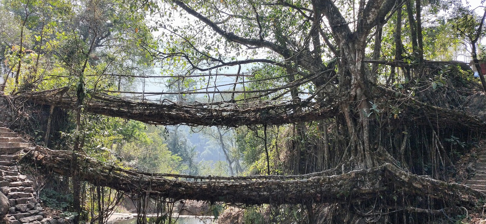
Meghalaya is a land of living root bridges, and double decker living root bridge of Nongriat is a special one that has two levels. It is a trek down of 3500 steps to reach here. It is recommended to start the trek very early in the morning. Guides are available for hire here.

We started the trek at 8:00 am and carried breakfast with us. The trek has cement stairs at more places along the slopes of the hill. Along the way, we cross few small streams and couple of single level root bridges. It took us 1:45 mins to reach the double decker bridge. There is a small waterfall and a stream near the double decker bridge. From here, you can trek further to reach Rainbow and NohaKalikai falls though we didn't do that in the interest of time. After exploring the bridge and doing photography, we started the return journey upwards. There are small shops along the way, as well as drinking water outlets. We finally reached the top at 1:15 pm, headed straight to Jiva resort for a well-earned lunch!

There are students here who do this trekking everyday to reach their school.

Dawki/Shnongpdeng


Wah Umngot (Dawki River)

Further south of Cherrapunji, along the Bangladesh border is the town called Dawki. The road is along the hills, and as we reach near Bangaldesh, climate will be a bit hotter.

Along the way, we stopped at Mawlynnong, Asia's cleanest village. It's small village, and also has a living root bridge. Dawki is the last town on Indian side of the border, which is connected to Tamabil of Bangladesh by  road. We visited India Bangladesh Friendship Gate which is the entry point for either country.

From here, we went to Shnonpdeng, a small village established along the Wah Umngot (Dawki River). The stay here was in wooden cottages constructed along the slope, though one can book tents as well. Cottages provides direct view of river. This is one of the cleanest rivers, with river bottom visible. We did boating in this river for close to an hour. There are also options for kayaking and snorkeling. Crossing the suspending bridge over the river is a must act, and gives a good view of the river. River is full of pebbles and stones, and sitting here with feet soaked in river water is a calming experience.

During rains the river becomes muddy, but January onwards the river has crystal clear water. 


At Kaziranga Cultural Center
More pics can be found at - https://www.instagram.com/nimeshddesai

November 28, 2018

Bhutan - The land of happiness


We visited this beautiful country during November 2018, and it turned out to be one of the most memorable experiences. This mountain country is neither too rich not too poor. It has monarchy with democratic government reporting to the King. Bhutan is what India could be with lesser population, better respect for each other and gratitude.

Bhutan is located between India and China, and is well connected by road with India. Roads in Bhutan are maintained in collaboration with India under Dantak project.

We were lucky to have Pasang Tshering (or PK) as our guide and friend there. He took care of all the travels, hotel accommodations and food. He also made us familiar with the Bhutanese culture, history and art. Bhutan was the first country visited by India's current Prime Minister Narendra Modi, and PK  was quite happy about this!

Reaching Bhutan:
  • The only airport of Bhutan is in the hilly regions of Paro, and Druk Air provides flights from Delhi/Kolkata, though these are quite costly.
  • Nearest Indian airport is Bagdogra in northern West Bengal. Bhutan border is usually a 4 hour road journey from Bagdogra, though keep in mind the traffic if you have a return flight to catch.
Best time to travel:
  • Except the months of monsoon, Bhutan can be explored during any season, though in each season, we might see different shades of Bhutan. September-October are good for people who want to do rafting or prefer lesser cold. It gets colder from November onwards, with peak during January. March/April provides scenic views during Spring.


View from Khamsum Yulley Namgyal Chorten

During our travel, we covered Phuensholing, Thimphu, Punakha/Wangdue and Paro. All these are quite small towns compared to big populous cities. Travel from one town to another is mostly along river on mountain roads, and those journeys are very soothing experiences. It can suddenly get cold as we approach pass (or La in Bhutanese), so keep the winter clothes ready.

Ngultrum is Bhutanese currency, but Indian currency is easily accepted in Bhutan at most the places. Both can be used interchangeably as they have the same valuation.

Interesting trivia - 1:
There were no televisions in Bhutan prior to 1999., and Bhutanese people are fond of Indian music, especially 70-80s Bollywood.

 
Our Travel Itinerary

Phuentsholing


Phuentsholing is an entry point to Bhutan from India. India-Bhutan share an open border here, separated by a wall. On the Indian side, there is Jaigaon of WB. One can easily move between two countries through gates. We stayed at Hotel Namgay during our arrival and departure. Bhutan timezone is 30 minutes ahead of India, so make sure to calibrate your watches here. So on Indian side of border you may have 5:00 pm, while just a few steps away at Bhutanese side, it will be 5:30 pm!

Phuentsholing itself is a very small, clean town, stark in contrast to its Indian neighbour Jaigaon.  One can do a walk around the town, visit the monastery and park here. This is where the immigration is done to enter the hilly regions of Bhutan.

For immigration, one would require to submit id proof (Aadhar/Passport), travel itinerary and photographs. Remember that immigration office is closed on weekends and it takes 1 to 2 hours to get the immigration done. Plan your travel accordingly to get it done in the morning.

On the way from Phuentsholing to Thimphu (near Dantak canteen)

Thimphu


Once you cross Phuensholing, the mountains of Bhutan starts. Our next destination was the capital city, Thimphu. It is a 5 hour journey from Phuensholing to Thimphu. We cross small villages/towns like Gedu, Chukha along the way, as well as famous Dantak canteen. An Indian meal at the canteen is recommended. This road provides multiple water falls, river valleys for the photo enthusiasts.

Thimphu is the place where the King lives, in this beautiful town surrounded by the mountains and blessed by Buddha. With a population of hardly 1.15 L, staying here is a calming experience.  We stayed at Hotel Kenny during our Thimphu journey.

Thimphu - as seen from Buddha Dordenma

Places to visit:
  • Buddha Dordenma
    • Probably the biggest sitting Buddha statue (54 mtr) in the world, this place is a must-see in one's Bhutan itinerary. The statue is located on top a mountain, overseeing Thimphu town. There is a chorten below the statue that houses 1,25,000 small Buddha statues.
  • Folk Heritage Museum
    • Museum showcases a traditional Bhutanese house.
  • National Institute for Zorig Chusum
    • Art and craft school
  • Bhutanese Paper Factory
One can also see King's Palace, Assembly Building and Thimphu town from a view point. There are other places like Memorial Chorten that we only visited from outside.

Buddha Dordenma
Food:
  • Though Bhutan is known for its non-veg variety of dishes, one can find chapati, rice, daal and mix-veg in most parts. Do try veg cheese momos at Zombala restaurant.

Interesting trivia - 2:
There are 20 Dzongkhag (districts) in Bhutan, each having their Dzong, an administration and religious fortress.


DoChu La


DoChu La Memorial

DoChu La is the highest point between Thimphu to Punakha. There are 108 memorial chortens built by former queen in honour of the Bhutanese soldiers who were killed in the December 2003 battle against Assamese insurgents from India, and to commemorate King's victory.

One can see Himalayan mountains from this point given the sky is clean. Bhutan's highest mountain Mt. Gangkar Puensum is also visible from here. There is also a monastery and a cafeteria at the pass.

Punakha/Wangdue Phodrang


Punakha Dzong

Our next destination was Bajo town of Wangdue Phodrang. Bajo is a well-maintained town, with monastery and children park, and small parallel lanes. This is where we also enjoyed traditional Bhutanese food, Kewa Datshi (Potato Cheese). Ema Datshi (Chilli Cheese) and Shamu Datshi (Mushroom Cheese), along with Karela (bitter gourd). We stayed at Hotel Rigsum in Bajo town.

Places to see:
  • Punakha Dzong
    • This is one of the most significant Dzong in Bhutan. The Dzong is located at the confluence of Pho Chu and Mo Chu rivers. This where Royal coronation and Royal weddings take place. Dzong has giant statues of Buddha, Padmasambhava and Zhabdrung. The administrative unit of Dzong also houses a bodhi tree. This is where the festivals are celebrated.
  • Khamsum Yulley Namgyal Chorten
    • 9 km from Punakha Dzong along the Mo Chu river, is Khamsum Yulley Namgyal Chorten. The chorten is located on a hilltop, and it is a 45 minute trek to reach there. It's a 3 storeyed chorten that provides stunning views of the river and mountains from the top.
  • Suspension Bridge
    • At 160 mtr, Punakha's suspension bridge is the longest in Bhutan. Walk on this 160 mtr suspension bridge over Pho Chu river brings mixed feelings of fun and fear! One can enjoy ice cream and other snacks on the other side of the bridge.
We also went to river beach under Wangdue Phodrang Dzong in a chilling cold, and enjoyed hot tea on the near-by bridge. There is also Chhimi Ihakhang in this region, where we didn't go.

Interesting trivia - 3:
Bhutan's total population is only 7.5 lakhs. One can only be a citizen of Bhutan by birth, that too when both the parents are of Bhutanese origin.

Chele La


Sunset at Chele La

Chele La is one of the highest pass in Bhutan. It is an hour drive from Paro, located at the altitude of 3988 mtrs. We saw yaks, Himalayan monal and other wildlife along the way. There is also a point on the route from where Paro airport can be seen from the top.  The weather at top is windy and chilly, and it was even difficult to keep the hands out. We reached there at 5:00 pm, and were lucky to see the sunset. By the time we returned, the outside temperature was already 2°C at the pass.

Interesting trivia - 4:
There is no railway line in Bhutan. Also there are no road tunnels in the mountains.


Paro


Our last destination on this trip before returning to Phuentsholing was Paro. Compared to Thimphu, Paro weather is much chilly, but it provides a nice clean sky at night with lot of stars. Bhutan's only airport is also located here, and it is a nice drive parallel to the runway. Surrounded by mountains on all four sides, it is one of the most difficult airport to navigate. We stayed at Hotel Silver Pine in Paro.

Like other Dzongkhags, Paro has it's own Dzong. There is also a National library of Bhutan here. We didn't go to both of these places, but rather explored local market and even got good herbs.

Paro Takshang (Tiger's Nest)


Takshang Monastery

Taksang monastery is a holy sight in Buddhism. It is believed that Padmasambhava (Guru Rinpoche) flew to this location from Tibet on the back of a tigress, and did meditation here. The monastery was destroyed in a fire in 1990s, but was re-built. It is a sight worth visiting.

Takshang base is a half an hour journey from Paro. From the base, it is a three hour trek to reach the monastery. Most part of the trek is on muddy mountain, with steep steps near monastery. We started early at around 9:00 am, and came back by 3:00 pm. The trek is long and requires reasonable physical efforts, but can be done by people of all age group. We met small kids and seniors, and even blind person, during the trek. There is a cafeteria half way in case you need to reenergise yourself.

We would recommend having traditional hot stone bath after the trek. There are few resorts in Paro providing this facility, and it is worth doing it. Herbs are added in the hot water, and it takes away all the fatigue.

Note:
  • Carry minimum luggage while doing the climbing. Instance energy snacks are good to have.
  • Keep a water bottle. There are multiple places from where water can be re-filled.

Interesting trivia - 5:
Primary and secondary education is free in Bhutanese schools. If the student scores well, Bhutanese government also give scholarship for further studies in India.


With Pasang Tshering, our freind and guide

More pics can be found at - https://www.instagram.com/nimeshddesai


December 23, 2016

A Trip to Himachal - Part 2 - McLeod Ganj

Second Destination: McLeod Ganj

How we reached there:

Khajjiar -> McLeod Ganj (via Jot, Chowari, Dharamshala) : Hired Taxi, takes 4.5 hours
McLeod Ganj -> Amritsar -> Pathankot : Hired Taxi, takes 5 hours to Amritsar and 2 hours to Pathankot from there

Places to stay:

There are number of options available on oyorooms, makemytrip and goibibo as well on HPTDC. You’ll get good home-stay as well. Prefer hotels near main square. We stayed in Hotel Castle (through oyorooms), near on Bhagsu Road.

Places to eat ( esp vegetarian ):

McLeod Ganj has a range of food options for Tibetan, Italian and Indian food. Some of our favourites are:
  • Nick’s Italian Kitchen
  • Hotel Tibet
  • Chocolate Log
  • Spring Valley Restaurant
      Needless to say that one must try momos in this part of the World, and apart from restaurants, there are road-side eateries offering good momos.

      Places to visit:

      From nature to history to religion to cricket, McLeod Ganj and Dharamshala has everything one can ask for.

      • Namgyal Monastery/Dalai Lama Temple and Tibetan Museum
      • McLeod Ganj is an official residence of His Holiness Dalai Lama and a headquarter of Tibetan government in exile. Dalai Lama stays at Namgyal monastery which is a must visit place. This buddhist monastery has spiritual aura that brings instant calmness.  Chants of 'Om Mani Padme Hung' and Prayer wheels are essential parts of this unique experience.

        There is also Tibetan museum within the temple premises, highlighting struggles of Tibetan people and their migration from Lhasa to India. 

      • Norbulingka Institute
      • Located near Dharamshala, this institute is named after Norbulingka, the traditional summer residence of the Dalai Lamas, in Lhasa, Tibet. It is aimed to preserve Tibetan tradition and provide training, education and employment to Tibetans. You can see Tibetan metal art, drawings and other artistic forms in action here. Losel Doll Museum is quite interesting. There is a souvenir shop to collect memories. And while you are at it, do try ginger lemon honey tea!
      • Bhagsunag Waterfall
      • Earlier morning visit to Bhagsunag Temple, trek to Bhagsunag waterfall and visit to Shiva cafe is another important thing to do while you are in McLeod Ganj. Bhagsunag Shiv Temple is located near the taxi stand on Bhagsunag road. Everything is anyway at a walking distance in McLeod Ganj. It's a 1.5 km trek to the waterfall from the temple, normally takes 30 mins. The trek is scenic, and the waterfall is chilly. Then you trek further up to Shiva cafe. It provides a nice view to the valley on one side, and Triund mountain on the other. Cafe provides variety of food option if you are tired after the trek.
      • HPCA Stadium
      • This famous Dharamshala cricket stadium is a sight to visit. Surrounded by mountains, it is one of most scenic cricket stadium around the world. Entry is free when there are no matches and you can go up to visitor's gallery.
      • Kangra war memorial
      • This is one of the location that our cab driver took us to while roaming around in Dharamshala. This war memorial is built in the memories of the martyrs of Kangra valley.
      Apart from these places, walks on the streets from main square to monastery are a must once you are in McLeod Ganj. Slope adds much fun to those evening walks. Located on both sides of the streets are various shops to satisfy your shopping urge. And don't miss the sunset from there!

      HPCA Stadium

      Bhagsunag Waterfall

      Shiva Cafe

      What next?

      After a three day stay at McLeod Ganj, we went to Amritsar, which is a 4.5 hrs drive from here, during our return journey. I had already covered Amritsar in my earlier post, but the location has changed significantly in these 7 years. We spent the afternoon at the Golden Temple and enjoyed food @ langar. Next we went to Jallianwala Bagh, the famous historic place, adjacent to the temple. We did go to Delhi after this, but could only cover Rajghat, Humayun's Tomb and Qutub Minar before our return flight to Pune.

      Humayun's Tomb

      December 19, 2016

      A Trip to Himachal - Part 1 - Khajjiar

      How we reached there:

      Pune -> Pathannkot : Train journey via Jelum Express, takes 38 hours
      Pathankot -> Khajjiar (via Dalhousie) : Hired Taxi, takes 4 hours, keep the stomach empty as it will be a roller-coster hill-side ride

      Places to stay:

      Khajjiar - Hotel Devdar, a part of HPTDC hotels, provides the best possible location for this place. Apart from this, there are other options like Mini-Swiss facing other side of mountain.

      Places to eat ( esp vegetarian food ):

      • Hotel Iravati in Chamba has wonderful dishes of Gucchi (a kind of Mushroom) and Chamba Kadhi.
      • Street-side food options, esp Parathas, are quite good in this part of the region

      So after a continuous journey of close to 43 hours, we finally reached our HPTDC Hotel Devdar in Khajjiar during the early part of noon. The lush green meadows in front of us instantly removed all the tiredness. Khajjiar is a very tiny hill station of Himachal, sometimes referred to as a Switzerland of India. It has a centrally located small lake, and surrounding meadows on slope all around. It is surrounded by trees and mountains from all side making it picture-perfect. There is a Khajjiar Nag temple, based on which this place is named ‘Khajjiar’. There are small treks all around, and morning walk towards other side to see sunset is worth the efforts. There is also a vaishnodevi temple at a walking distance, with huge Shiva statue.

      Things to do:

      During day time, the meadow is full of activities with tourists coming there from near-by places. Horse-riding is quite common. Grass and slope offers sports like Zorbing, which is a must try. One can also do paragliding on the other side of the mountain.

      Nearby Places:

      • Chamba: At 22 km distance from Khajjiar, Chamba is located along the river Ravi. Laxmi Narayan Temple is a must visit place there. There is also a Bhuri Singh Museum to know a bit of history of the place. If you are lucky, may get to see cricket match in the central Chamba ground!
      • Dalhousie: Dalhousie is yet another hilltop tourist place, with Tibetan market and a lot of street shopping. There is a wildlife sanctuary, Kala Top, on the way to Dalhousie. This road also takes you along multiple hillside schools.


      (Part 2 will take you to McLeod Ganj and ahead)