Showing posts with label Travel. Show all posts

January 21, 2023

Arunachal Pradesh Diary : Chapter 4 - Bum La and North Tawang

We started our Arunachal Pradesh journey from the Guwahati Airport. We explored Dirang and Bomdila in Chapter 1. From there, we reached Tawang in Chapter 2. Once in Tawang, we covered the nearby places in Chapter 3. Now, in the final chapter of our Arunachal journey, we'll be going north of Tawang, along the snow-capped mountains, exploring the beauty of Himalayas and ultimately reaching the China border at the Bumla pass.

It is recommended to read journey so-far in earlier chapters before continuing.

Travel Advisory:

Tawang is at the altitude of approx. 10000 ft. The altitude will keep on increasing during the journey towards the north of Tawang. So it is advisable to get used to the altitude and climate.

Y-Junction

We started our journey towards the Gurudwara and Sungester lake at around 9 am from Tawang. After crossing the town, our upward journey continued in the mountains. While the distances in kms might look smaller, it takes reasonable time to cover these places as the entire journey is on narrow mountain roads. At about 21 kms from Tawang, there is a junction known as Y-junction. As the name suggests, there are two roads going in different directions from this place. The straight one goes towards Sungester lake while the right turn goes towards the Bumla pass.


With Jawans near Y-Junction

While the climate was quite cold, to our pleasant surprise, we witnessed snow fall as we reached the Y-junction. It suddenly became too cold and we were lucky to find an army shop. We not only purchased some winter clothes, but were also offered delicious food by the jawans. The snow fall was quite heavy and we enjoyed it despite extreme cold.

Note:

  • Carry extra winter clothes, including gloves, while going north of Tawang. The weather changes quite quickly here. Be extra careful if you are planning for a solo bike trip.

Gurudwara Teesri Udassi

As this was the day of Diwali, our first stop was Gurudwara Teesri Udassi. This is a small Gurudwara is located on the hill, and normally takes 20-30 minutes to climb a rather steep slope. Unfortunately, we could only go till halfway as the snowfall had made air quite thin and it became difficult to even breathe while climbing. We bowed down in respect to Guru Nanak Dev and climbed down. The langar is setup at the base only and we had a wonderful tea and sweets in the open langar. 

This is the gurudwara where Guru Nanak Dev stayed during his voyage to Tibet.


At the base of Gurudwara Teesri Udassi

T-Gompa

From the Gurudwara, we continued our journey despite snowfall and rain. We finally reached a small monastery called, Takshang Gompa (T-Gompa). This small but beautiful monastery holds a lot of significance in the Tibetan Buddhist history. When His Holiness 14th Dalai Lama escaped from Lhasa in March 1959, he entered India via this route and stayed at this monastery.


Takshang Gompa


Sungester Lake

From the monastery, we started our return journey, and finally reached the famous Sungester lake. This side of Tawang is quite known for its lakes and we crossed quite a few during this trip. While we didn't spend much time at other lakes due to lack of time, we did explore the beautiful Sungester lake. We had our lunch in a small cafe/restaurant near the lake. Thankfully the rain had stopped by now which allowed us to spend some quality time here. A collection of submerged black trees give this lake a distinct look. The lake became famous after the shooting of movie Koyla here, starring Madhuri Dixit. Therefore this lake is also known as Madhuri lake. 

Sungester lake was created by an earthquake in 1973.


Sungester Lake

While the water is quite cold, you can explore the lake surroundings and enjoy the scenic beauty. Clear lake water surrounded by mountains makes it quite a picturesque location. Here also there is an army camp that offers winter clothes and other accessories at quite an affordable prices.

After Sungester lake, we finally headed towards Tawang and it became quite dark by the time we reached back at 4:30 pm. Our BRO friends invited us to their temple for the celebration of Diwali in the evening. This Diwali celebration in BRO campus will remain one of the most memorable event of our trip.

Bum La

As the roads near border area were closed due to heavy snow fall, we spent next few days exploring places nearby Tawang as highlighted in Chapter 3. This also allowed ourselves getting used to the climate. Finally, we started our journey towards the Bumla pass one morning. Being a sensitive border area, you'll need to obtain a permit to go to Bum La. This can be obtained online.

We again crossed the Y-junction and this time took the right turn towards Bum La. While the road to Bum La was open, the vehicle movement was quite slow due to earlier snowfall. It took us more than 2 hours to finally reach Bumla. We crossed beautiful snowcapped mountains and Joginder Singh Memorial along the route.


On the way to Bum La

At 15,200 ft, Bum La is one of the highest border pass, and road to Bumla is maintained by BRO under Project Vartak. There is a reception area where visitors wait while waiting for their batch. Nice hot soup, samosa and kaju katli is available in the canteen here. You can see the border from the reception room glass window. As our number came, we walked up to the India-China Border gate on a small road under the guidance of an army officer. Photography is not permitted here. The officer passionately told about the history of Bumla, 1962 war and the sacrifice of Subedar Joginder Singh. There was a layer of thick snow all round and therefore there is no fencing along this border. The climate changes suddenly here and it can become quite cold within a few minutes. 

Subedar Joginder Singh was awarded Param Vir Chakra for his bravery during the battle of Bum La on 23 October 1962.

Bum La

The air of Bum La still smells the sacrifices of brave Indian soldiers of the battle fought 60 years ago. The battle is still on for the soldiers here as they face the harsh weather and a hostile neighbor. It is quite unfortunate for a heaven like Bum La to remain a politically sensitive area.

We had a plan to go up to the holy Chumi Gyatse waterfall along the India-China border and spend a night there. Unfortunately, the roads were closed due to heavy snowfall on that route. We therefore returned back to Tawang from Bum La. There is always something left for which we may return to this mesmerizing land again in future.

As we reach end of our journey, again a moment of appreciation for the BRO (Border Road Organization) that takes care of the road infrastructure in this difficult terrain. Many thanks to Gaurav Gupta sir, Rakesh Bhatti sir, Zuber Ahmad Sir and others from BRO whose warmth and hospitality we'll never forget.

Our good friends, Nini and Jay whom we met during this trip, have covered the places of Tawang quite beautifully in their vblog here  -


Like education, travel is also an investment that pays rich dividends, and this particular investment has indeed been such a case. On that note, ending the Amazing Arunachal Chapter here.

January 13, 2023

Arunachal Pradesh Diary : Chapter 3 - Tawang

In Chapter 2 of this blog series, we finally reached Tawang after exploring Bomdila, Dirang and all the wonderful places along the route. It is recommended to go through Chapter 1 and Chapter 2 before continuing on this journey here. We stayed in Tawang for 5 nights at Jambey Villa homestay, and this became our base to explore the near-by places. It is here in Tawang where we met our friends from BRO who made our stay extra-special. We even got to celebrate Diwali in BRO temple.

Places to stay:

  • While Tawang is one of the least populated districts in the country, this town located on the mountain does have a good number of places to stay for the travelers. You can find good hotels and homestays to stay during your journey.
Food:
  • While all types of non-veg food is quite easily available in Tawang, it was not difficult to find veg food as well. We found decent parathas and momos at the Delhi Darbar restaurant in town. 

Travel Advisory:
  • Tawang is located at approx. 10000 ft (3,048 m) above sea level. The weather is also cold especially as the night approaches. It takes some time for the body to get adjust to these conditions especially when we travel from the plains of Guwahati. Therefore, it is recommended to not have a hectic scheduled and keep buffer of extra days while planning your trip. This will be also handy in case some roads are blocked due to snow fall or rain.

In this blog, we'll cover places located near Tawang. These include some of the famous monasteries of Tawang as well as our visit to nearby villages. The journey to Bumla and places along that route to be covered in the subsequent blogs.

Monasteries

Being a Buddhist town, Tawang has a number of monasteries, some of which hold a lot of historical and spiritual significance. We managed to cover below mentioned three monasteries, but missed out on a beautiful Nunnery, Gyangong Ani Gompa, located around 5 km from the town, due to bad weather. 

Tawang Monastery

The beautiful and historic Tawang Monastery is also known as the Tawang Ganden Namgyal Lhatse. The monastery has an 8 mtr tall Lord Buddha in the sanctum. Monastery has a residential building for the monks, a library, a museum and school for the basic education. The yellow rooftop residential building gives it a distinct look. The monastery is located at about 2 km from the town and it is better to visit it during the morning.

The Twanag Monastery is the oldest monastery in India and is the second biggest monastery in Asia.


Tawang Monastery

Urgeling Monastery

Urgeling monastery is located about 5 kms from the main town. This simple monastery was built around 1487 and was founded by Ugyen Sangpo. This place is the birth place of Tsangyang Gyatso, the 6th Dalai Lama. There is a holy tree in the compound of this monastery which is said to be planted by the 6th Dalai Lama. 


Urgeling Monastery

Khinmey Nyingma Monastery

Khinmey Nyingma Monastery also known as Sang-ngag-choekhorling. It is located at about 8 kms from Tawang in the Khinmey village. The main prayer hall has the statue of Buddhist sage Padmasambhava. The monastery was founded in 1440. His Eminence the 14th Thegtse Rinpoche is the current head of this monastery. The monastery provides accommodation and guidance to hundreds of monk students.


Khinmey Nyingma Monastery

Tawang War Memorial

The border town of Tawang has witnessed 1962 India-China war. Despite difficult geography, extreme weather and limited equipment, Indian army soldiers put a brave effort defending the country against much a superior armed force. Tawang War memorial is a beautiful stupa built in the memory of those brave soldiers.

The names of the brave soldiers of 1962 war who fought on this front are written around the central stupa.


Tawang War memorial

The memorial is located within the area of armed forces and there is a 30 minute light-n-sound show in the evening near memorial, depicting cultural heritage of Arunachal Pradesh and stories of 1962 war. As seating capacity is limited, make sure to reach on time for the show. The start time varies as per season, but normally it is 5:00 pm in winter and 6:30 pm in summer. There is a souvenir shop near by to collect memories. 


Lumla

During our trip, we also explored some offbeat locations, not frequently visited by the regular tourists. One such location was a beautiful Lumla village, located approx. 40 kms from the Tawang town towards the eastern Bhutan border. There is a scenic waterfall as we enter Lumla with a well constructed viewing platform. Just opposite to the waterfall, on the main road, is Lobsang restaurant. We recommend having your lunch here as not many food options are there in the mail Lumla village.

Lumla is known for its Tara Devi Temple. The temple is mainly visited by the local Buddhist population. The chanting of monks inside the temple creates a divine aura. There is a big Tara Devi statue on top of the temple which gives it a unique view.


Tara Devi Temple, Lumla


On our way back to Tawang from Lumla, we also stopped by the Mahabodhi School in Teli village. The entrance of the residential school has many white stupas on one side of the road. The center was inaugurated in 2016 by the Chief Minister. Mahabodhi runs an integrated program where senior citizens and children are living together like in an extended family.


Chagzam Bridge

Yet another offbeat location around Tawang is the historic Chagzham Bridge. We explored this during our return journey from Tawang. This suspension bridge is more than 600 years old. It was built by Tangton Gyalpo, a disciple of the first Dalai Lama using iron chains, over Tawang-chu river to connect to a monastery. The bridge is of religious significance to the locals and is believed to fulfil the wishes of devotees. There is also a newer suspension bridge built adjacent to the original Chagzam bridge.

Chagzam Bridge is a 100 mtr long suspension bridge.
 

Chagzam Bridge

Tawang Cultural Festival

Tawang Festival is quite a popular event of Arunachal Pradesh that celebrates the culture of Monpa tribes. Unfortunately, November 2022 Tawang Festival was called off due to some reason. Luckily for us, our young driver Nima took us to attend the Shyo Village Cultural Event one evening. The event had four folk dances, depicting different stories. It even had the famous snow lion dance. The snow lions and bulls do come to audience as well during their performances.


With Snow Lions at Shyo Cultural Event


After exploring Tawang, we'll head north to go to the famous India-China border at Bumla pass and the places located on the north side of Tawang in our final chapter. Stay tuned for the updates as the things are going to be quite chilly.

January 7, 2023

Arunachal Pradesh Diary : Chapter 2 - From Dirang to Tawang

In the Chapter 1 of this series, we entered Arunachal Pradesh via South-Western border and reached up to Dirang. In this chapter, we'll continue our 135 km northward  journey towards Tawang.

Our first stop on this journey was a place called Padma, a popular spot to have food. Padma has a few roadside restaurants/stores where you can get anything from chocolates to drinks to momos. We had our best veg momos of this trip at Padma. It is recommended to full your belly here as there are not many food points ahead.

Nyukmadong War Memorial


Nyukmadong War Memorial

Just ahead of Padma, there is Nyukmadong War Memorial. The Nyukmadong War Memorial is built overlooking the famous battle ground of 18 Nov 1962. The main memorial is a 'Chorten' and the names of soldiers who died in this battle are engraved in stones around this Chorten. This beautiful memorial pays homage to the supreme sacrifice of Indian Army soldiers.

Sela Pass


Sela Lake

After visiting the memorial, we continued our journey on the beautiful Himalayan mountain roads. The height continuously increases as we cross the various Army cantonments along the journey. The highest point on this route is the Sela Pass, located at 13700 ft.  This is where we enter the Tawang district. Due to its height, the region is quite cold, and it often snows here. We were lucky to have clear weather during our onward trip which allowed us to explore the scenic Sela Lake located on this pass. 

The pass holds a lot of significance to the local Buddhist community. You'll see a lot of colorful Buddhist flags here. It is named after a tribal woman Sela who fought along side Jaswant Singh Rawat during the 1962 India-China war. The pass is also important to connect Tawang to the Assam and for the movement of the goods. As it sometimes gets closed due to heavy snow, a tunnel is being built to ensure 365 day connectivity.

Jaswant Garh War Memorial

After Sela Pass, we'll continue traveling on the mountain roads through ups and downs. Approx. 25 kms from Sela Pass is our next stop - Jaswant Garh War Memorial. 


Jaswant Garh War Memorial

The story of Rifleman Jaswant Singh Rawat is that of the battle of Nuranang, on 17 November 1962. Even after 60 years of the war, Rifleman Jaswant Singh is still considered to be serving and on duty. The memorial is built on the location of this battle and to pay homage to Rifleman Jaswant Singh and the Gorkha rifles.

The canteen of Jaswant Garh memorial offers decent food. The army store is also there for winter cloth shopping or to collect souvenirs. This was the place from where we first started seeing the snowcapped mountains. After having some light snacks and tea, we continued our downward journey towards the next stop.

Jang Falls

Nuranang Falls/Jang Falls

Nuranang Falls is located near the Jang town, and are also known as Jang Falls. This 100 mtr tall waterfalls is a popular tourist destination for the locals. The milky waterfalls is famous for its rainbow formations and we were lucky to see the colorful rainbow formed due to the mist formed by the waterfall. The waterfall is on the Nuranang river which merged into the Tawang river at the base of the waterfall. There is small cafe near the base of the waterfall along side the river.

Jang Falls is located approx. 40 kms before Tawang. Our journey along the mountain roads continued after spending some time at the waterfall, and we finally reached our homestay in Tawang during late evening. Details of our Tawang journey is now available in Chapter 3.


December 25, 2022

Arunachal Pradesh Diary : Chapter 1 - Bomdila and Dirang

Travel is an investment in oneself. 

Ever since our first trip to the North-East India in 2019, we were eager to come back and explore the hidden gems. The pandemic delayed the next big travel, but finally we got a chance to come to the land of rising Sun, Arunachal Pradesh, in October 2022.


Mountains Calling

Arunachal Pradesh was formed from the earlier NEFA (North-East Frontier Agency). It is a border state having international borders with China, Myanmar and Bhutan. This hilly region of Himalayas has witnessed the 1962 India-China war. Our trip was on the western side of Arunachal, covering Dirang, Tawang and Bumla. In the first chapter, our focus will be on Bomdila and Dirang.


Before we begin, a moment of appreciation for the BRO (Border Road Organization) that takes care of the road infrastructure in this difficult terrain. They are continuously improving the road infrastructure in this region to make it all-weather accessible. Many thanks to Gaurav Gupta sir, Rakesh Bhatti sir, Zuber Ahmad Sir and others from BRO whose hospitality made our trip extra special.

How to reach:

  • Nearest airport is Guwahati Airport. The road journey from Guwahati to Tawang is better to be broken into 2 days due to the hilly region.
  • We stayed in Dirang  (Dirang Dzong homestay) during our onward journey and stayed near Sappers with our BRO friends during the return journey. 
  • The towns in Arunachal are located on the hills and are sparsely populated. The journey on the mountain roads is mostly along the side of the river. 

Weather:

  • Once you enter Arunachal Pradesh via land route, the altitude keeps on rising and temperature keeps on falling. Keep your winter clothes ready.
  • Extreme winter starts November month onwards, but the cold climate remains throughout the year. It can be understood by the observation that there were no fans in any homestays we stayed!

Culture:

  • While Christianity is a major religion in Arunachal Pradesh, people of the Western districts of West Kameng and Tawang are mostly Buddhist. 
  • Hindi is quite commonly used by the locals in communication.

Bomdila

We entered Arunachal Pradesh via Balemu check point, quite close to the Bhutan border. As Arunachal Pradesh comes under the restricted area, you'll need Inter-Line Permit (ILP) to enter the state. It can be obtained online.

We crossed picturesque views of Kalaktang and Rupa before reaching Bomdila. This was an 10-hour journey from the Guwahati Airport. The mountain roads are full of cabbage plantations on this route.  Bomdila is a headquarter of the West Kameng district. Bomdila is mainly famous for the beautiful Bomdila monastery. We spent a quite evening here exploring the monastery.


Bomdila Monastery

A drone view of the same monastery can be seen on the YouTube channel of our friends Nini and Jay who met us first time at this Monastery. - https://www.youtube.com/watch?v=taHxMGkmIVw

Dirang

Dirang is at an hour's distance from Bomdila. This is where we had our first stay at the Dirang Dzong homestay. During our return, we stayed at Sappers which is quite close to Dirang. The beautiful hilly region of Dirang was a pleasant surprise for us. For the nature lovers, this place has a lot to offer. 


Seven Brothers' Monument, Dirang

There is a monument in the memory of seven brothers who laid down their lives protesting against the tyrant king along side the road. The old Dirang Monastery was at walkable distance from our stay. It is a small monastery and was under renovation during our visit. The new Thuksang Dargeyling Monastery was built recently in 2017 and was inaugurated by his Holiness the 14th Dalai Lama. The new monastery is located on a hill top and it takes approx. 30 minutes to reach there. If you are looking for calmness and peace, this scenic monastery has got plenty of them. This beautiful structure overlooking Dirang offers great visuals for photographers.


Thuksang Dargeyling Monastery


Dirang is also a good base to explore nearby locations, like Mandala Top and Sangti Valley. Mandala Top, as the name suggests, is located on the top of a mountain, approx. 25 kms from Dirang. On a non-cloudy day, the hairpin road offers scenic view of the surrounding mountain ranges. On top, there is a recently constructed circular monument of 108 stupas. This is a good place for a day picnic.


Mandala Top

While Mandala Top is located on the top of a hill, Sangti Valley offers a picturesque location of a village along the river. The road to reach valley is not smooth but it crosses beautiful plantations of oranges, tomatoes and kiwis. The white sandy river beach of valley is a good place to relax and enjoy the chilled water. There are homestay available near the valley to stay here overnight. That would be quite an experience for sure.


Sangti Valley

We had planned our trip for Tawang, but Dirang came out as a beautiful surprise. There are few more surprises on our journey towards Tawang, to be explored in the subsequent chapters!

Head to the Chapter 2 here.

More photos of Arunachal trip can be seen at - https://www.instagram.com/nimeshddesai/

April 20, 2019

Assam and Meghalaya - God's Own Abode

India is a country full of surprises with so much diversity in its geography, culture and heritage. There are places with which you will instantly fall in love with. North-east is one such region. Each state is unique, with its own cultural identity, liberally blessed by nature.


We started planning for our trip in January 2019 along with our friends our friends Srihari and Anu. We explored different options, finalised plans, and did all the booking. Finally, we visited Assam and Meghalaya in March 2018. We pre-booked our transport, Innova crysta, for the entire journey. Nripen was our driver and companion who took us to the wonderlands of Assam and Meghalaya. His expertise about the region helped us cover everything that we planned for.

While across India there is common timezone (IST), do keep in mind the changed (early) routine of sunrise and sunsets if traveling here from western part of India.

Reaching Assam and Meghalaya

  • Guwahati has a military airport where domestic flights also operate. There are regular flights to Guwahati from all major cities of India.
  • There is an excellent road connectivity between Assam and Meghalaya. It is a 4 hour road journey from Guwahati to Shillong.
Best time to travel
  • Every season offers different reason to travel this beautiful world. Monsoons starts April onwards, and it is a good time for monsoon lovers who want to witness heavy rains. But some of the places, like Kaziranaga remains closed during monsoon, and Dawki river may not be as clean as it is during summer. February/March is end of summer and is generally a good time when most places can be explored.
We started our journey from Lokpriya Gopinath Bordoloi International Airport of Guwahati. We explored Guwahati, Kaziranga, Shillong, Cherrapunji (Sohra) and Shnongpdeng. These places are well connected by road. While Assam is mostly flat lands, majority journey through Meghalaya is on mountain roads.

Guwahati


Guwahati as seen from Bhubneswari Temple

Guwahati is one of the major cities in north-east region, located close to the capital of Assam, Dispur. Located on the banks of Brahmputra, this city is known for its temples. Our stay here was at Baruah Bhawan, a walking distance from the riverbank.

Places to see
  • Kamakhya Temple : Kamakhya is one of most famous temple of north east India. It is located on a small hill, where one can reach by car. It is usually very crowded and takes 5-6 hours for the darshan. We were lucky to do it within 2 hours. Try to reach early in the morning. Further on top of the hill is Bhubneswari Temple, from where a beautiful view of Guwahati is visible.

We also went to Navagraha temple and Umananda temple (on the peacock island in Brahmaputra) here, and crossed Saraighat bridge and IIT Guwahati. Guwahati market is good for Assamese Mekhla saree shopping, and delicious rasgullas.


Kaziranga National Park


Rhino at Kaziranga National Park

215 km from Guwahati, is World Heritage site of Kaziranga National Park. Famous for its Indian one-horned rhinoceros, the sanctuary is also a home to a wide range of animals and birds like Royal Bengal Tigers, Wild Elephants, Swamp Deers, Wild buffaloes, King cobra, tortoise, hornbills, eagles, vultures and stokes. Kaziranga is a part of Golaghat and Nagaon district, and spread across the area of 430 square kms along the Bramhputra river.

There are three major entry gates, western (Bagori), central (Kohora) and eastern (Agaratoli). Decent stay options are available here. We stayed at Sneha Bhawan which was closer to Kohora gate.

Things to do

  • Elephant safari : Exploring the forest on the back of an elephant is an experience to remember. Every morning there are safaris that need to be pre-booked. Elephant safaris covers appx 15 sq km area, and takes us very close to rhinos and other animals. 
  • Jeep safari : Jeep safari covers much larger area, and takes us deep inside the forest. We did multiple jeep safaris, from Bagori and Kohora gates respectively. This is enjoyed best by remaining quiet, observing the surroundings and listening to forest movements. Though we missed tiger by 10 mins, We saw hornbills, eagles, vultures, monitor lizard, rhinos, swamp deers, wild elephants, stokes, variety of tortoise and many different birds.
  • Cultural Program at Kaziranga National Orchid And Biodiversity Park : After the hectic day that was spent mostly in the forest of Kaziranga, this cultural program provides a soothing relief. The group here performs various traditional dance forms and live music, and they are exceptional. There are souvenir shops to carry back memories.

Kaziranga remains closed for visitors during monsoon, May 1 to Oct 31.

Shillong


Airforce Museum
Shillong is a capital of Meghalaya and 3 hr journey from Guwahati. It's a scenic journey as most part of it is in hilly regions. We took a halt at Umiam lake to see the wonderful sunset. Shillong was the coldest place in our trip, and temperature drop is significant. We stayed at the wonderful and well maintained Pine Hill Homestay.

Places to see
  • Elephant falls : This is one of landmarks of Shillong. You'll see couple of waterfalls along the small trek.
  • Airforce museum : Shillong is the head quarter of eastern airforce, and a visit to airforce museum is highly recommended. Museum also has a souvenir shop.
  • Shillong View Point: On top of the hill, within airforce area is a point that provides scenic view of Shillong city. It takes some time getting the entry here due to security reasons. Remember to carry id cards while going here.
We also went to Ward's lake, and explored Police Bazaar area for shopping. City Hut Dhaba is a recommended place for lunch/dinner.

Police Bazaar market remains closed on Sunday, so plan your trip accordingly if you are interested in shopping.


Cherrapunji/Sohra


Nohakalikai Falls

65 km south of Shillong is Cherrapunji, which is locally known as Sohra. It is famous for its rainfall, and we did get a glimpse of it during one of the nights.

On the way from Shillong to Cherrapunji, there are some good places to explore. Meghalaya comprises of large number of caves in Jaintia, Khasi and Garos hills, and few of them are a must visit.

  • Arwah Lumshya Cave : Arwah Lumshya is a natural cave formed within the limestone rock. Along with stalactites and stalagmites, this cave has presence of fossils along its walls and roofs. Journey to the entrance of this cave from the parking is also quite scenic within the forest.
  • Mawsmai Cave: This is another limestone cave that provides good view of the natural formations. Some of the passages are very narrow, and adds to the thrill.
  • Nohakalikai Waterfalls: Nohkalikai Falls is the tallest plunge waterfall in India with the height of l115 feet. It is located quite close to the main town.
There are other waterfalls as well like Wah Kaba and Seven sisters (which is actually beyond Cherrapunji) in this region. Our stay here was at La Kupar, which was quite well maintained, offers campfire and provides amazing night sky view. Orange roots restaurant on this way offers good food.

Nongriat - Double Docker Living Root Bridge


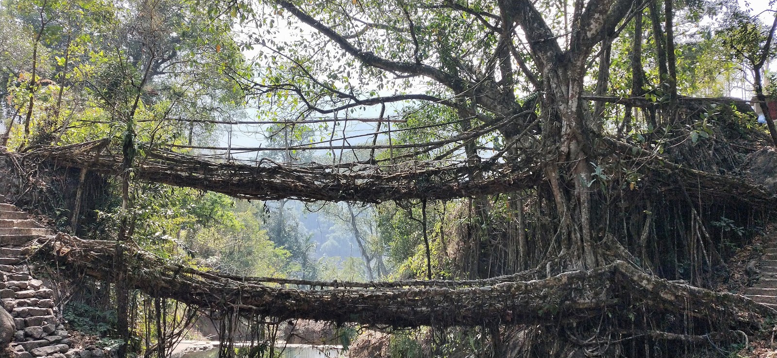
Double Decker Living Root Bridge

Meghalaya is a land of living root bridges, and double decker living root bridge of Nongriat is a special one that has two levels. It is a trek down of 3500 steps to reach here. It is recommended to start the trek very early in the morning. Guides are available for hire here.

We started the trek at 8:00 am and carried breakfast with us. The trek has cement stairs at more places along the slopes of the hill. Along the way, we cross few small streams and couple of single level root bridges. It took us 1:45 mins to reach the double decker bridge. There is a small waterfall and a stream near the double decker bridge. From here, you can trek further to reach Rainbow and NohaKalikai falls though we didn't do that in the interest of time. After exploring the bridge and doing photography, we started the return journey upwards. There are small shops along the way, as well as drinking water outlets. We finally reached the top at 1:15 pm, headed straight to Jiva resort for a well-earned lunch!

There are students here who do this trekking everyday to reach their school.

Dawki/Shnongpdeng


Wah Umngot (Dawki River)

Further south of Cherrapunji, along the Bangladesh border is the town called Dawki. The road is along the hills, and as we reach near Bangaldesh, climate will be a bit hotter.

Along the way, we stopped at Mawlynnong, Asia's cleanest village. It's small village, and also has a living root bridge. Dawki is the last town on Indian side of the border, which is connected to Tamabil of Bangladesh by  road. We visited India Bangladesh Friendship Gate which is the entry point for either country.

From here, we went to Shnonpdeng, a small village established along the Wah Umngot (Dawki River). The stay here was in wooden cottages constructed along the slope, though one can book tents as well. Cottages provides direct view of river. This is one of the cleanest rivers, with river bottom visible. We did boating in this river for close to an hour. There are also options for kayaking and snorkeling. Crossing the suspending bridge over the river is a must act, and gives a good view of the river. River is full of pebbles and stones, and sitting here with feet soaked in river water is a calming experience.

During rains the river becomes muddy, but January onwards the river has crystal clear water. 


At Kaziranga Cultural Center
More pics can be found at - https://www.instagram.com/nimeshddesai

November 28, 2018

Bhutan - The land of happiness


We visited this beautiful country during November 2018, and it turned out to be one of the most memorable experiences. This mountain country is neither too rich not too poor. It has monarchy with democratic government reporting to the King. Bhutan is what India could be with lesser population, better respect for each other and gratitude.

Bhutan is located between India and China, and is well connected by road with India. Roads in Bhutan are maintained in collaboration with India under Dantak project.

We were lucky to have Pasang Tshering (or PK) as our guide and friend there. He took care of all the travels, hotel accommodations and food. He also made us familiar with the Bhutanese culture, history and art. Bhutan was the first country visited by India's current Prime Minister Narendra Modi, and PK  was quite happy about this!

Reaching Bhutan:
  • The only airport of Bhutan is in the hilly regions of Paro, and Druk Air provides flights from Delhi/Kolkata, though these are quite costly.
  • Nearest Indian airport is Bagdogra in northern West Bengal. Bhutan border is usually a 4 hour road journey from Bagdogra, though keep in mind the traffic if you have a return flight to catch.
Best time to travel:
  • Except the months of monsoon, Bhutan can be explored during any season, though in each season, we might see different shades of Bhutan. September-October are good for people who want to do rafting or prefer lesser cold. It gets colder from November onwards, with peak during January. March/April provides scenic views during Spring.


View from Khamsum Yulley Namgyal Chorten

During our travel, we covered Phuensholing, Thimphu, Punakha/Wangdue and Paro. All these are quite small towns compared to big populous cities. Travel from one town to another is mostly along river on mountain roads, and those journeys are very soothing experiences. It can suddenly get cold as we approach pass (or La in Bhutanese), so keep the winter clothes ready.

Ngultrum is Bhutanese currency, but Indian currency is easily accepted in Bhutan at most the places. Both can be used interchangeably as they have the same valuation.

Interesting trivia - 1:
There were no televisions in Bhutan prior to 1999., and Bhutanese people are fond of Indian music, especially 70-80s Bollywood.

 
Our Travel Itinerary

Phuentsholing


Phuentsholing is an entry point to Bhutan from India. India-Bhutan share an open border here, separated by a wall. On the Indian side, there is Jaigaon of WB. One can easily move between two countries through gates. We stayed at Hotel Namgay during our arrival and departure. Bhutan timezone is 30 minutes ahead of India, so make sure to calibrate your watches here. So on Indian side of border you may have 5:00 pm, while just a few steps away at Bhutanese side, it will be 5:30 pm!

Phuentsholing itself is a very small, clean town, stark in contrast to its Indian neighbour Jaigaon.  One can do a walk around the town, visit the monastery and park here. This is where the immigration is done to enter the hilly regions of Bhutan.

For immigration, one would require to submit id proof (Aadhar/Passport), travel itinerary and photographs. Remember that immigration office is closed on weekends and it takes 1 to 2 hours to get the immigration done. Plan your travel accordingly to get it done in the morning.

On the way from Phuentsholing to Thimphu (near Dantak canteen)

Thimphu


Once you cross Phuensholing, the mountains of Bhutan starts. Our next destination was the capital city, Thimphu. It is a 5 hour journey from Phuensholing to Thimphu. We cross small villages/towns like Gedu, Chukha along the way, as well as famous Dantak canteen. An Indian meal at the canteen is recommended. This road provides multiple water falls, river valleys for the photo enthusiasts.

Thimphu is the place where the King lives, in this beautiful town surrounded by the mountains and blessed by Buddha. With a population of hardly 1.15 L, staying here is a calming experience.  We stayed at Hotel Kenny during our Thimphu journey.

Thimphu - as seen from Buddha Dordenma

Places to visit:
  • Buddha Dordenma
    • Probably the biggest sitting Buddha statue (54 mtr) in the world, this place is a must-see in one's Bhutan itinerary. The statue is located on top a mountain, overseeing Thimphu town. There is a chorten below the statue that houses 1,25,000 small Buddha statues.
  • Folk Heritage Museum
    • Museum showcases a traditional Bhutanese house.
  • National Institute for Zorig Chusum
    • Art and craft school
  • Bhutanese Paper Factory
One can also see King's Palace, Assembly Building and Thimphu town from a view point. There are other places like Memorial Chorten that we only visited from outside.

Buddha Dordenma
Food:
  • Though Bhutan is known for its non-veg variety of dishes, one can find chapati, rice, daal and mix-veg in most parts. Do try veg cheese momos at Zombala restaurant.

Interesting trivia - 2:
There are 20 Dzongkhag (districts) in Bhutan, each having their Dzong, an administration and religious fortress.


DoChu La


DoChu La Memorial

DoChu La is the highest point between Thimphu to Punakha. There are 108 memorial chortens built by former queen in honour of the Bhutanese soldiers who were killed in the December 2003 battle against Assamese insurgents from India, and to commemorate King's victory.

One can see Himalayan mountains from this point given the sky is clean. Bhutan's highest mountain Mt. Gangkar Puensum is also visible from here. There is also a monastery and a cafeteria at the pass.

Punakha/Wangdue Phodrang


Punakha Dzong

Our next destination was Bajo town of Wangdue Phodrang. Bajo is a well-maintained town, with monastery and children park, and small parallel lanes. This is where we also enjoyed traditional Bhutanese food, Kewa Datshi (Potato Cheese). Ema Datshi (Chilli Cheese) and Shamu Datshi (Mushroom Cheese), along with Karela (bitter gourd). We stayed at Hotel Rigsum in Bajo town.

Places to see:
  • Punakha Dzong
    • This is one of the most significant Dzong in Bhutan. The Dzong is located at the confluence of Pho Chu and Mo Chu rivers. This where Royal coronation and Royal weddings take place. Dzong has giant statues of Buddha, Padmasambhava and Zhabdrung. The administrative unit of Dzong also houses a bodhi tree. This is where the festivals are celebrated.
  • Khamsum Yulley Namgyal Chorten
    • 9 km from Punakha Dzong along the Mo Chu river, is Khamsum Yulley Namgyal Chorten. The chorten is located on a hilltop, and it is a 45 minute trek to reach there. It's a 3 storeyed chorten that provides stunning views of the river and mountains from the top.
  • Suspension Bridge
    • At 160 mtr, Punakha's suspension bridge is the longest in Bhutan. Walk on this 160 mtr suspension bridge over Pho Chu river brings mixed feelings of fun and fear! One can enjoy ice cream and other snacks on the other side of the bridge.
We also went to river beach under Wangdue Phodrang Dzong in a chilling cold, and enjoyed hot tea on the near-by bridge. There is also Chhimi Ihakhang in this region, where we didn't go.

Interesting trivia - 3:
Bhutan's total population is only 7.5 lakhs. One can only be a citizen of Bhutan by birth, that too when both the parents are of Bhutanese origin.

Chele La


Sunset at Chele La

Chele La is one of the highest pass in Bhutan. It is an hour drive from Paro, located at the altitude of 3988 mtrs. We saw yaks, Himalayan monal and other wildlife along the way. There is also a point on the route from where Paro airport can be seen from the top.  The weather at top is windy and chilly, and it was even difficult to keep the hands out. We reached there at 5:00 pm, and were lucky to see the sunset. By the time we returned, the outside temperature was already 2°C at the pass.

Interesting trivia - 4:
There is no railway line in Bhutan. Also there are no road tunnels in the mountains.


Paro


Our last destination on this trip before returning to Phuentsholing was Paro. Compared to Thimphu, Paro weather is much chilly, but it provides a nice clean sky at night with lot of stars. Bhutan's only airport is also located here, and it is a nice drive parallel to the runway. Surrounded by mountains on all four sides, it is one of the most difficult airport to navigate. We stayed at Hotel Silver Pine in Paro.

Like other Dzongkhags, Paro has it's own Dzong. There is also a National library of Bhutan here. We didn't go to both of these places, but rather explored local market and even got good herbs.

Paro Takshang (Tiger's Nest)


Takshang Monastery

Taksang monastery is a holy sight in Buddhism. It is believed that Padmasambhava (Guru Rinpoche) flew to this location from Tibet on the back of a tigress, and did meditation here. The monastery was destroyed in a fire in 1990s, but was re-built. It is a sight worth visiting.

Takshang base is a half an hour journey from Paro. From the base, it is a three hour trek to reach the monastery. Most part of the trek is on muddy mountain, with steep steps near monastery. We started early at around 9:00 am, and came back by 3:00 pm. The trek is long and requires reasonable physical efforts, but can be done by people of all age group. We met small kids and seniors, and even blind person, during the trek. There is a cafeteria half way in case you need to reenergise yourself.

We would recommend having traditional hot stone bath after the trek. There are few resorts in Paro providing this facility, and it is worth doing it. Herbs are added in the hot water, and it takes away all the fatigue.

Note:
  • Carry minimum luggage while doing the climbing. Instance energy snacks are good to have.
  • Keep a water bottle. There are multiple places from where water can be re-filled.

Interesting trivia - 5:
Primary and secondary education is free in Bhutanese schools. If the student scores well, Bhutanese government also give scholarship for further studies in India.


With Pasang Tshering, our freind and guide

More pics can be found at - https://www.instagram.com/nimeshddesai


July 20, 2009

Haridwar

Haridwar is one of the most visited holy city of Hindu pilgrims. It is a part of Uttarakhand, which is famously called DevBhoomi or Divine Land. I have visited Haridwar many a times during my days at IIT Roorkee, which is just 25 kms away from here. But this time, I managed to travel the breadth and width of Haridwar to the greater extent. Haridwar is well connected by train and bus routes with Delhi and Dehradun. One can easily find an inter-state transport bus to Haridwar on regular basis. We took bus from Roorkee and it took us around 40 minutes to finally arrive at this Holy city. There is a subtle change in the atmosphere once you drop down at Haridwar bus depot or railway station. I have never seen so many pilgrims in any holy place in India, and they keep coming in all the seasons throughout the year. It is believed that the revenues earned from Haridwar plays a major role in state Uttarakhand's budget.


Har ki Paudi

There are many places to visit in Haridwar and surrounding area, but your trip to Haridwar is incomplete unless you visit the famous Har ki Paudi(or Har ki Pauri) ganga ghat. This place has its own value in Hindu mythology and every Hindu wish to visit this place once in his/her life time. From dawn to just before dusk, the atmosphere is pretty normal here. People come and take a dip in the river Ganges (Ganga) at the nicely constructed ghat. As the sunset approaches, more and more people start gathering here for the prayer of river Ganga. There are a few temples on the ghat of Har ki Paudi, mainly of river Ganga or of Lord Shankar (father of Ganga). The priests come out of these temples to perform worship of Ganga. This atmosphere is pleasant to the eyes. The prayers continue for about 40 minutes and then slowly crowd disperses. The sight of Mansa devi temple on top of the hill is also a worth watch from Har ki Paudi during evening.


Temples

While Har ki Paudi remains the main tourist and religious spot in Haridwar, there are many temples in Haridwar which are also worth visiting. We heard from someone that there are so many temples in Haridwar that it will take more than a week to visit them all! Luckily we got a very good rickshaw chalak who knew of the good temples there and took us there for nominal charges. We visited 7 temples in 3 hours and I must say, some of them are really unique and nicely built. I am writing here about the temples I liked the most.
First let me talk about Vaishno devi temple, which is also called Bharat Darshan. I will refer to it as Vaishno devi temple to avoid confusion with another temple I'll write later. Vaishno devi temple is about three storey in height. From the entrance you can see big idols of Hanumanji, Ganeshji and Surya rath. With nominal fees one can enter in the temple. Then we have to follow a specific route which takes you to all the Gods and Goddesses of India and finally to Vaishno devi tunnel. One has to crawl through the tunnel to see Mata Vaishno deviand take her blessings. The whole idea of this temple is to give devotee a feel of original Vaishno devi trip.
The second temple, which is also the last one we visited, is Bharat Mata temple. This temple is totally different from all the temples you might have seen in your lifetime. It is built specifically to give tribute to Bharat Mata or India. It is very tall, having 7 floors. Each floor is dedicated to a particular element of Indian culture. At one floor you will find all the Gods, at another all Goddesses. There are also floors for our freedom fighters, ancient heroes and noble people. There is floor which gives you an overview of all the Indian states and their cultures, and of different religions. In short, the entire temple is like a mini Bharat.